Overture Maps GERS, an open standard for interoperable geospatial IDs

The Overture Maps Foundation is focused on continuing what it calls its “collaborative efforts” to build interoperable open map data.
The foundation has now announced Global Entity Reference System (GERS), a standard to provide a unique ID for every geospatial entity.
The idea is to make it easier to build mapping solutions across industries such as automotive, local search, urban planning, ride-sharing and logistics.
Mapping applications and spatial analysis have benefited from many new data types, but at a cost i.e. combining data from various sources requires time and money to ensure that the data is correctly associated with the right entities in the map.
That cost to evaluate and conflate data can exceed the cost of licensing the data, which ultimately will discourage its use.
GERS IDs
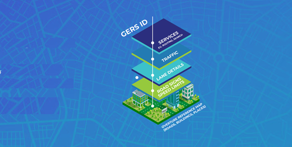
The GERS IDs enable organisations to join datasets, share information and onboard new data using open and accessible identifiers.
GERS IDs are a defining characteristic of Overture’s open map datasets. Each “entity” in the base maps carries a unique ID, including 2.6 billion buildings, 64 million places, nearly 447 million addresses, and 321 million road segments. These datasets form the foundational layers for anyone building mapping applications and are governed by open source data licenses, allowing free use in applications and analyses.
By incorporating GERS IDs into any data that needs to be associated with those base layers, users can easily combine relevant data to build richer applications.
“When we started Overture almost three years ago, we knew that to remake the geospatial industry, we had to solve the problems of adding rich data to the map. GERS does this and is the most impactful innovation of the Overture Maps Foundation so far,” said executive director Marc Prioleau, Overture Maps Foundation. “It will drive innovation that impacts billions of consumers as well as companies, governments, and organisations globally. We fully expect it to become the standard around which the geospatial industry aligns.”
Because spatial data is collected and described differently by various sources, it often costs more to onboard and integrate that data into mapping solutions – and to make sure it works with other data – than to license it in the first place.
Hidden tax of data integration
Many data teams lack the expertise or resources to handle complex geospatial data management. As such, organisations may avoid incorporating new data to mapping solutions, limiting the richness and utility of their applications.
“Data conflation is a hidden tax on the data ecosystem. It affects everyone working with data from multiple sources. GERS can end that tax,” said Microsoft VP, Jeffrey Hightower. “Without GERS IDs, organisations spend weeks getting data into their systems. With GERS, new data can be added in minutes to geospatial entities such as buildings, roads, places, and addresses, making it far easier to build rich applications.”
By associating data (such as population or traffic) with GERS IDs for entities such as geographic boundaries or transportation segments, companies can make data connections with simple column joins rather than complex data conflations.
GERS is open
Other ID systems exist in mapping today, but many are controlled by a single company. Overture data and GERS IDs are open, which means anyone can use it without restrictive licensing. Data can be matched to the open base layers via GERS without risk of vendor lock-in.
GERS IDs refer to entities like buildings, addresses, road segments, or places. This allows data to be associated with greater specificity than IDs based on latitude and longitude.
More information on GERS is here.